
Download GPX or view the route on ViewRanger.
Length: 7 miles.
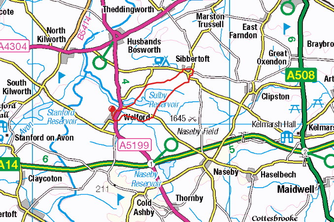
Location: Roadside parking in Welford, 25 minutes east of Rugby.
Date: 28/5/2015
A fairly flat route on well way-marked field paths and farm tracks, this was a gently enjoyable circular route, joining two villages on the north-west edge of Northamptonshire.
If you look on an OS map, there are two fairly obvious footpaths linking Welford and Sibbertoft: the Jurassic Way over Sulby Reservoir, and a bridleway a little to the east which brings you back down again. This route follows those two footpaths.
Starting in Welford, parking on the road by the same church we started a previous walk at, the route turns right, past the church, and out through the village, with a mix of older and newer houses, including some with very Butterfield-esque brickwork. This joins the major road through the village, where the route turns left, passing a statue of Postman Pat, and then right, crossing a bridge over a very stream-like River Avon.


At this point we join the Jurassic Way, as it follows a track around, and then over, a reservoir, or rather two, because on the left side of the weir is Welford Reservoir, filled with fish (and fishermen), while on the right is the wildlife reserve of Sulby Reservoir.


On the other side of the weir we enter fields, first through the ever-present field of rape, but then over grass, and over the remains of the long-deserted medieval village of Old Sulby.


(New) Sulby itself is a collection of a couple of farm houses, which we pass to the left of, finding a surfaced farm track via a discreet stile in the corner of a field. You probably won’t have the helicopter repeatedly buzzing over you, practising low level flying, that I did! The route passes a very random (and, I imagine, little used) post box, a small solar farm, and more fields using this farm track, before branching off to the left, reaching the road into Sibbertoft five fields later.


Rather than going straight through Sibbertoft, the route turns left along a side-street, then across a couple of fields to approach the back of a very handsome looking church, with benches making an excellent location for a half-way snack stop.


Once out of the church grounds, we turn right, and wend our way back out of Sibbertoft, past old red-brick cottages, a road sign with oddly Australian overtones, and a war memorial.


The route soon leaves the road, joining a signed bridleway, but turning right at an unmarked gap in the hedge, rather than follow the ‘Battlefield Trail’ which is signed in front of you. This seems to be part of the Nasby Battlefield Project, linking together some of the areas involved in a key battle of the English Civil War. The path continues straight over flat fields, slowly descending then turning right to head into a small wood.


As bright as the day was outside, in the wood everything was much darker and more muted, with a surprisingly wide variety of bird song. Here’s a 45 second clip I recorded:
This felt like a worthy reward for the 15 minutes of slightly boring field walking, and the muddy conditions underfoot. Eventually the trail led to a farm track, which left the wood and led to the Naseby to Welford road. Across the road, the route continues, this time following Shakespeare’s Avon Way, with a good view to Welford on the horizon. These are the grounds of Sulby Abbey, and you cross over some earthworks as you descend a field, to reach a tiny stream which will eventually become the River Avon. You will also, almost certainly, meet a wide selection of cows.


As cows go, these weren’t too bad, mostly moving out of the way obligingly when I got close. My general strategy in cow fields is to make sure I introduce myself to them and tell them what I’m about to do, which would probably give me some strange looks from passers by…
After a few fields passed by, the route moved away from the river, and up to the left hand field edge, curving around to the southern edge of Welford. By this point I was feeling a little tired, and started singing to myself to keep myself moving at a decent speed, confusing the sheep I walked past.


Once back on the main road, the starting point is down the very next lane on the left, past some very recently renovated thatched houses.


Overall, this was an enjoyable stroll through the north-west Northamptonshire countryside. There is enough variety in the different parts of the walk to keep your interest up, and the field routes were all accessible and fairly well signposted.

Postman pat was carved by http://www.mrshep.com
Thank you for the link to your work!